|
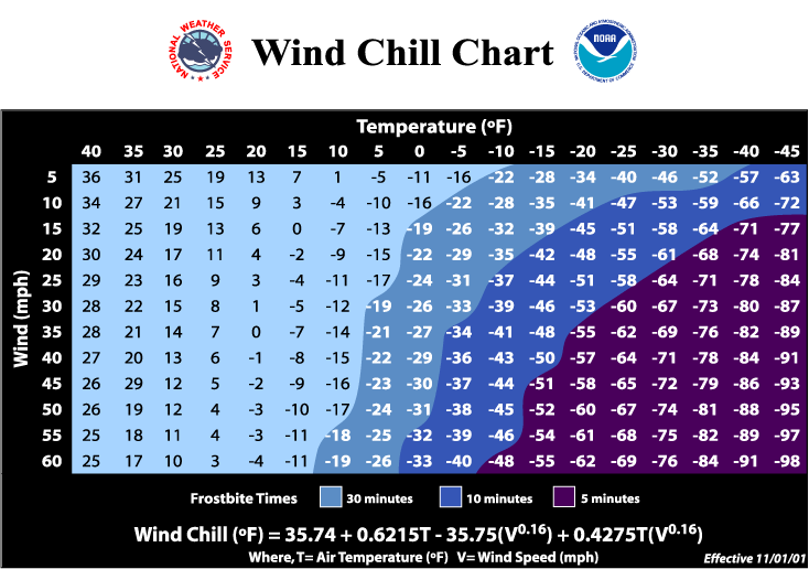
Wind chill temperature is a measure of the combined cooling effect of wind and temperature. As wind increases, heat is carried away from the body at a faster rate, driving down both the skin temperature (which can cause frostbite) and eventually the internal body temperature (which can kill). The Wind Chill Temperature index is the measure of this relationship.
This page can be used to compute the new Wind Chill Temperature index. The National Weather Service and the Meteorological Services of Canada has implemented the new Wind Chill Temperature index for the 2001/2002 winter season. The reason for the change is to improve upon the previous index which was based on the 1945 Siple and Passel Index. (More)
Enter desired values for temperature and wind speed in the appropriate boxes, then press Compute.
Note that the Wind Chill is only defined for temperatures in the range -45oF to +45oF and wind speeds 3 to 60 mph. Note also that water will not freeze unless its temperature (not the wind chill temperature) reaches the freezing point. Wind Chill FAQs
Experimental Temperature/Wind Chill Probability Outlook from the NWS Climate Prediction Center

History: The earliest wind chill index was based on the research of Antarctic explorers Siple and Passel who first measured the combined impacts of varying wind speed and freezing temperatures in 1945. They did this by measuring heat loss from water as it froze in a plastic container suspended from a tall pole.
For over a year, there have been discussions between the National Weather Service and the Meteorological Services of Canada about updating the Wind Chill Temperature Index. During the Fall of 2000, a special group – consisting of the National Weather Service, the Meteorological Services of Canada and the International Society of Biometeorology – evaluated the existing wind chill formula and made changes to improve it. The group's goal was to internationally upgrade and standardize the Wind Chill Temperature Index.
The new Wind Chill Temperature Index, by Randall Osczevski of DCIEM and Maurice Bluestein of Purdue University in Indiana, makes use of advances in science, technology and computer modelling to provide a more accurate, understandable and useful formula for estimating the dangers arising from winter winds and freezing temperatures. In addition, clinical trials were conducted and the results of those trials has been used to verify and improve the accuracy of the new formula.
Twelve volunteers (six men and six women) participated in the clinical trials. These consisted in four walks, at 4.8 km/h, on a treadmill in a refrigerated wind tunnel at the Defence and Civil Institute of Environmental Medicine in Toronto, Canada: one walk at each of -10°, 0° and +10°C, plus a "wet trial" at +10° during which participants received, every 15 seconds, a light one-second splash of water in their faces. During each 90-minute walk, the volunteers were walking while facing a wind of 2 metres per second (m/s) for 30 minutes, followed by 30 minutes at 5 m/s, and 30 minutes at 8 m/s (or about 4, 10 and 16 mph, respectively). Sensors were fixed to participants' forehead, cheeks, chin and nose, as well as to the inside of one cheek, to measure skin temperature and heat loss. The results from these trials were used to determine the various thresholds for frostbite, as seen on the new wind chill chart.
The new wind chill equation is now in use in both Canada and the United States. Therefore, there is now a consistent wind chill formula across North America.
The Wind Chill Temperature Index has been implemented in Canada and the United States, resulting in a consistent index provided to help the public protect itself against the dangers of frostbite and hypothermia.
Specifically, the new Wind Chill Temperature Index:
- uses calculated wind speed at an average height of five feet (typical height of a human face) based on readings from the national standard height of 33 feet (typical height of an anemometer);
- is based on the latest heat transfer theory, i.e., heat loss from the body to its surroundings, during cold and breezy/windy days;
- is based on a human face model because this is the part of the human body most often exposed to the elements;
- uses a standard factor for skin tissue and assumes a no sunlight scenario.
Frostbite Threshold: For the first time, the wind chill temperatures include specific threshold values that provide specific warning of time-to-frostbite at given levels of wind chill. For example, a temperature of 5 degrees Fahrenheit and a wind speed of 30 mph equal a wind chill of -19, which will produce frostbite in 30 minutes. The chart also shows how frostbite will occur sooner if the temperature is lower or the wind speed higher. Since it is the responsibility of the National Weather Service to help protect lives, this is an important service to the American people.
Clinical Testing Process: The new wind chill temperature index was tested on human volunteers at the wind tunnel and climatic chamber of the Defense and Civil Institute of Environmental Medicine in Toronto, Canada. In these tests, the faces of six men and six women were exposed to various temperatures and winds. By means of sensors attached to various parts of their bodies, researchers measured how fast the temperatures of the exposed skin dropped. A time-dependent model was used to determine the time of frostbite and the model incorporated the results from the tests.
Wind Chill FAQs
|


